By Rear Admiral Dr. S. Kulshrestha (Retd.), Indian Navy
By Rear Admiral Dr. S. Kulshrestha (Retd.)
“…[t]he main advantage of using drones is precisely that they are unmanned. With the operators safely tucked in air-conditioned rooms far away, there’s no pilot at risk of being killed or maimed in a crash. No pilot to be taken captive by enemy forces. No pilot to cause a diplomatic crisis if shot down in a “friendly country” while bombing or spying without official permission” [1]
- Medea Benjamin, 2013
The aim of this article is to look at some of the developments and the technological spinoffs that are likely to have a profound impact upon uninterrupted 24/7 gathering of real-time strategic intelligence, surveillance, and reconnaissance data.
Platforms
Image Attribute: X-37B Orbital Test Vehicle / Source: AF.mil
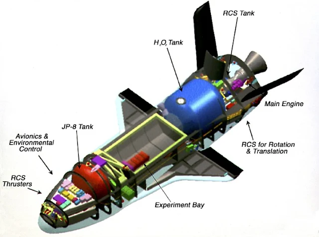
X-37 B. The X-37 B or the Orbital Test Vehicle [2] mystery aircraft of the US Air Force has nearly completed one year in orbit and it is not known when it will land. The X-37 B program has been shrouded in mystery since its inception sometime in 1999 as a NASA program. The X-37 B has a wingspan of 4.5m, a length of 8.9 m, a height of 2.9m [VG1] and a launch weight of 4990 kg. It is powered by GaAs solar cells and lithium-ion batteries after it is boosted into space. It can remain in orbit for periods of over one year. As per US Air Force fact sheet the mission of the X-37B Orbital Test Vehicle, or OTV, is “an experimental test program to demonstrate technologies for a reliable, reusable, unmanned space test platform for the U.S. Air Force. The primary objectives of the X-37B are twofold: reusable spacecraft technologies for America's future in space and operating experiments which can be returned to, and examined, on Earth”[3]. It states further that OTV missions till now have spent a total of 1,367 days in orbit, "successfully checking out the X-37B's reusable flight, re-entry and landing technologies." As per US Air Force fact sheet [4] some of the technologies being tested include advanced guidance, navigation and control, thermal protection systems, avionics, high-temperature structures and seals, conformal reusable insulation, lightweight electromechanical flight systems, advanced propulsion systems & autonomous orbital flight, reentry and landing. It is said that X-37 B has a XR-5A Hall Thruster made by Aerojet Rocketdyne and that it carries an experimental propulsion system developed by the US Air Force.
Image Attribute: Schematics of X-37B Orbital Test Vehicle / Source: Source: AF.mil
VULTURE
Image Attribute: An artistic impression of DARPA's VULTURE
VULTURE is an acronym for DARPA's Very-high altitude, Ultra-endurance, Loitering Theater Unmanned Reconnaissance Element [5] program. The objective of the Vulture program was to enable an uninterrupted ISR and communication missions spanning five years or more by remaining airborne at very high altitude. The VULTURE was envisaged to operate as a single platform, or as a formation of multiple aircraft, or as a constellation providing infrastructure augmentation/recovery. The project transformed into Boeing/Phantom Works Solareagle (VULTURE II) project, which aimed to reach that five-year endurance mark with its 120m wingspan but the project was canceled in 2012. Interestingly, both Facebook and Google have taken the lead from DARPA and have launched programs for ultra long endurance stratospheric drones.
High Altitude Airship
Image Attribute: The U.S. Army and Lockheed Martin launched the first-of-its kind High Altitude Long Endurance-Demonstrator on July 27, 2011, from the historic Akron Airdock. / Source: Lockheed Martin's Official Youtube Channel
The Lockheed Martin High Altitude Airship [6] (HAA™) is an un-tethered, unmanned lighter-than-air vehicle that is being designed to operate above the jet stream in a geostationary position to deliver persistent station keeping as a surveillance platform, telecommunications relay, or a weather observer. It will provide the military with, ever-present ISR, and rapid communications connectivity over the entire battle space. The airship is estimated to survey a 600-mile diameter area and millions of cubic miles of airspace.
Global Hawk
Image Attribute: RQ-4 Global Hawk / Source: U.S. Air Force photo by Bobbi Zapka
RQ-4 Global Hawk is the long-range, high-altitude ISR UAV of the US Air Force. It can fly for up to 32 hours at altitudes as high as 60,000 feet, with a range of 12,300 nautical miles [7], providing imaging and signals intelligence, as well as communications support, to troops around the world. It is battle proven and gives near-real-time, day and night, the all-weather high-resolution imagery of large geographical areas. The US Air Force plans to spend $4Bn on upgrading the Global Hawk drone program [8].
Triton MQ 4C
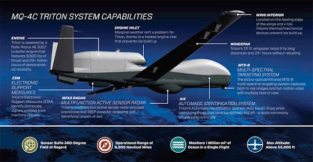
The U.S. Navy will continue with Triton MQ-4C that can stay aloft for over 24 hours at 17,000 m. It has speeds of up to 610 km/h [9]. Its surveillance sensor is the AN/ZPY-3 Multi-Function Active Sensor (MFAS) X-band AESA radar with a 360-degree field-of-regard, capable of surveying 7,000,000 sq km of sea. It utilizes the radar in inverse synthetic aperture mode [10] to identify a target in any weather condition and take high definition radar pictures, then uses the advanced image and radar return recognition software of the onboard automatic identification system (AIS) for classification.
Image Attribute: MQ-4C Triton System Capabilities / Source: Northrop Grumman Corporation
Sensors Packages
Gorgon Stare
In December 2015, the US DOD confirmed [11] that the Gorgon Stare wide-area airborne surveillance (WAAS) system had been incorporated in the Reaper MQ-9 UAV of the US Air Force missions flying over Afghanistan. The basic configuration of Gorgon Stare consists of five monochrome charge-coupled device (CCD) daylight cameras and four thermal cameras built into a 25-inch EO/IR turret with a separate pod for data links. The advanced version of the above is the Autonomous Real-Time Ground Ubiquitous Surveillance Imaging System, (ARGUS-IS).
Image Attribute: WIRED.com, Dated: Feb 19, 2009
ARGUS
The ARGUS-IS, is a DARPA project contracted to BAE Systems and is a type of wide-area persistent surveillance system[12]. It is a camera system that utilizes hundreds of mobile phone cameras in a mosaic to video and auto-track every moving object within a 36 square mile area. ARGUS-IS provides military users an "eyes-on" persistent wide-area surveillance capability to support tactical users in a dynamic battlespace or urban environment.
The sensor uses four lenses and 368 cell phone cameras of five megapixels each. The major components of the system are a 1.8 Gigapixels video system and its processing subsystems, in the air and on the ground. In early 2014, ARGUS-IS achieved initial operating capability (IOC) with the U.S. Air Force as part of Gorgon Stare Increment 2[13]. The system streams a million terabytes of HD video per day. The enormous amount of data can be stored indefinitely and subjected to review as and when required [14]. It is understood that ARGUS can be easily deployed on UAVs like Predator and HALE. The software utilized by ARGUS-IS is Persistics.
Image Attribute: The ARGUS-IS mission poster / Source: DARPA
The sensor uses four lenses and 368 cell phone cameras of five megapixels each. The major components of the system are a 1.8 Gigapixels video system and its processing subsystems, in the air and on the ground. In early 2014, ARGUS-IS achieved initial operating capability (IOC) with the U.S. Air Force as part of Gorgon Stare Increment 2[13]. The system streams a million terabytes of HD video per day. The enormous amount of data can be stored indefinitely and subjected to review as and when required [14]. It is understood that ARGUS can be easily deployed on UAVs like Predator and HALE. The software utilized by ARGUS-IS is Persistics.
Persistics, The Software
The brain for the handling of the immense amount of data gathered by the advanced surveillance cameras is a software program called Persistics developed by Lawrence Livermore National Laboratories. Fundamentally, it is a data compression program, which can compress the raw wide area video data from aircraft and UAVs 1000 times and achieve a reduction of pre-processed images by a factor of ten. Persistics compresses data that are essentially background data like jitter, static images of the background etc while retaining the images of military interest. The system functions by; carrying out video stabilization[15] using ‘pixel-level dense image correspondence’; background image compression; aligning image positions obtained from different cameras, and output images of moving objects with sub-pixel resolution.
Image Attribute: Three system integration with Persistics Software - Predators, MQ-9 Reaper Gorgon Stare and MQ-9 Reaper ARGUS-IS, an approved Wide Area Airborne Surveillance System by USAF (Joint Requirements Oversight Council Memorandum / JROCM 106-08, dated 27 May 08)
Inference
The military is moving rapidly towards gathering of strategic intelligence, surveillance, and reconnaissance data. The processing of such voluminous data is also being undertaken by advanced techniques utilizing artificial intelligence to a large extent. Nevertheless, the kill loop still takes considerable time from detection by the unmanned vehicles in the sky to activation of the armed response. Time is therefore ripe for the long endurance UAVs to start deploying armament on their pods. However, the automation of the drones to execute the kills on their own, without a human in the loop, is still some years away.
______________________________________________________________________________
About the Author:
RADM Dr. S. Kulshrestha (Retd.), INDIAN NAVY, holds expertise in quality assurance of naval armament and ammunition. He is an alumnus of the NDC and a Ph.D. from Jawaharlal Nehru University, New Delhi. He superannuated from the post of Director-General, Naval Armament Inspection in 2011. He is unaffiliated and writes in defense journals on issues related to Armament technology and indigenization.
Publication Details:
This article was originally published in a blog maintained by Centre for Land Warfare Studies, New Delhi and it is republished on IndraStra with the permission from Author and the Original Publisher. All Rights Reserved by Centre for Land Warfare Studies (CLAWS), New Delhi.
References
[1] Benjamin, Medea. 2013. Drone Warfare: Killing by Remote Control. New York, NY: Verso.
[2] David Leonard, Mystery Mission: Air Force's X-37B Space Plane Nears 1 Year in Orbit http://www.space.com/32839-x37b-military-space-plane-one-year-mission-otv4.html
[3] X-37B Orbital Test Vehicle http://www.af.mil/AboutUs/FactSheets/Display/tabid/224/Article/104539/x-37b-orbital-test-vehicle.aspx
[4] Ibid.
[5] VULTURE via GlobalSecurity.org http://www.globalsecurity.org/intell/systems/vulture.htm
[6] Unmanned Aerostats and Lighter Than Air Technology http://www.lockheedmartin.com/us/products/lighter-than-air-vehicles/haa.html
[7] Global Hawk -Vigilance for a Changing World http://www.northropgrumman.com/Capabilities/GlobalHawk/Pages/default.aspx
[8] Kevin McCaney, Air Force plans to spend $4B on Global Hawk drone program https://defensesystems.com/articles/2015/05/19/air-force-global-hawk-spending-plans.aspx
[9] MQ-4C Triton Making the World’s Oceans Smaller http://www.northropgrumman.com/Capabilities/Triton/Pages/default.aspx
[10] MQ-4C Triton DataSheet http://www.northropgrumman.com/Capabilities/Triton/Documents/pageDocuments/Triton_data_sheet.pdf
[11] http://www.janes.com/article/56720/dod-confirms-gorgon-stare-to-be-operational-in-afghanistan
[12] AUTONOMOUS REAL-TIME GROUND UBIQUITOUS
SURVEILLANCE IMAGING SYSTEM ARGUS-IS www.baesystems.com/en/download-en/20151124113917/1434554721803.pdf
[13] Stephen Trimble, Sierra Nevada fields ARGUS-IS upgrade to Gorgon Stare pod, https://www.flightglobal.com/news/articles/sierra-nevada-fields-argus-is-upgrade-to-gorgon-stare-400978/
[14] DARPA shows off 1.8-gigapixel surveillance drone, can spot a terrorist from 20,000 feet http://www.extremetech.com/extreme/146909-darpa-shows-off-1-8-gigapixel-surveillance-drone-can-spot-a-terrorist-from-20000-feet
[15] George I. Seffers, Coping With the Big Data Quagmire http://www.afcea.org/content/?q=coping-%E2%80%A8big-data-quagmire
[16] Matt Williams, SUPER SECRET X-37B NEARS ONE YEAR IN ORBIT DOING ??? http://www.universetoday.com/128879/super-secret-x-37b-nears-one-year-orbit/#


